Nelze vybrat více než 25 témat
Téma musí začínat písmenem nebo číslem, může obsahovat pomlčky („-“) a může být dlouhé až 35 znaků.
|
|
před 4 roky | |
|---|---|---|
| R | před 4 roky | |
| inst | před 4 roky | |
| man | před 4 roky | |
| tests | před 4 roky | |
| .Rbuildignore | před 4 roky | |
| .codecov.yml | před 4 roky | |
| .gitignore | před 4 roky | |
| .travis.yml | před 4 roky | |
| CONDUCT.md | před 4 roky | |
| DESCRIPTION | před 4 roky | |
| LICENSE | před 4 roky | |
| LICENSE.md | před 4 roky | |
| NAMESPACE | před 4 roky | |
| NEWS.md | před 4 roky | |
| README.Rmd | před 4 roky | |
| README.md | před 4 roky | |
| rradar.Rproj | před 4 roky | |
README.md

![]()
![]()

![]()
![]()
rradar
Animate NOAA NWSRadar Images by Station Id
Description
NOAA NWS has an array of National Doppler Radar Sites. Tools are provided to to help you locate stations and create an animated composite image of recent radar images.
What’s Inside The Tin
The following functions are implemented:
animate_conus_mosaic: Create an animated weather radar mosaic for the the conterminus U.S.animate_radar: Create an animated weather image from a NOAA stationlatest_radar: Read latest NWS regional or ConUS radar mosaics as a stars objectlatest_ridge: Read latest NWS ridge as a stars objectscale_fill_rradar: Continuous fill scale for use with NWS raster radar datastations: NOAA U.S. Radar Stations
Installation
install.packages("rradar", repos = "https://cinc.rud.is")
# or
remotes::install_git("https://git.rud.is/hrbrmstr/rradar.git")
# or
remotes::install_git("https://git.sr.ht/~hrbrmstr/rradar")
# or
remotes::install_gitlab("hrbrmstr/rradar")
# or
remotes::install_bitbucket("hrbrmstr/rradar")
# or
remotes::install_github("hrbrmstr/rradar")
NOTE: To use the ‘remotes’ install options you will need to have the {remotes} package installed.
Usage
library(rradar)

# current version
packageVersion("rradar")
## [1] '0.4.0'
Stations
library(tidyverse)

filter(stations, state == "Maine")
## # A tibble: 2 x 4
##   state city     dir   station
##   <chr> <chr>    <chr> <chr>
## 1 Maine Caribou  N0R   CBW
## 2 Maine Portland N0R   GYX

filter(stations, state == "California")
## # A tibble: 11 x 4
##    state      city             dir   station
##    <chr>      <chr>            <chr> <chr>
##  1 California Beale AFB        N0R   BBX
##  2 California Edwards AFB      N0R   EYX
##  3 California Eureka           N0R   BHX
##  4 California Hanford          N0R   HNX
##  5 California Los Angeles      N0R   VTX
##  6 California Sacramento       N0R   DAX
##  7 California San Diego        N0R   NKX
##  8 California San Francisco    N0R   MUX
##  9 California San Joaquin Vly. N0R   HNX
## 10 California Santa Ana Mtns   N0R   SOX
## 11 California Vandenberg AFB   N0R   VBX
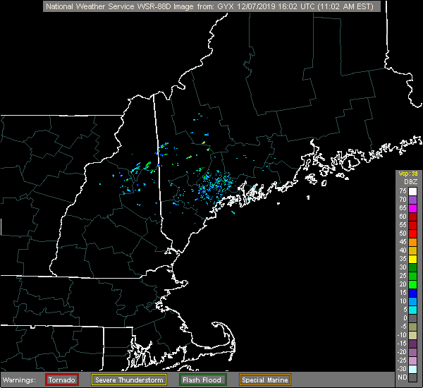
animate_radar("GYX")
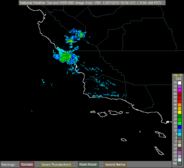
animate_radar("VBX")
animate_conus_mosaic("small")

library(sf)
library(stars)
library(rradar)
library(viridis)
library(rnaturalearth)
library(hrbrthemes)
library(tidyverse)

wrld <- ne_countries(scale = "medium", country = c("united states of america", "canada"),
                     continent = "north america", returnclass = "sf")
us <- ne_states("united states of america", returnclass = "sf")

ne_radar <- latest_radar("northeast")

wrld <- st_crop(wrld, st_bbox(ne_radar))
us <- st_crop(us, st_bbox(ne_radar))

ggplot() +
  geom_sf(data = wrld, size = 0.125, fill = '#fefefe') +
  geom_sf(data = us, size = 0.125, fill = '#fefefe') +
  geom_stars(data = ne_radar) +
  coord_sf(datum = NA) +
  scale_fill_rradar() +
  labs(
    x = NULL, y = NULL,
    title = "NWS Radar Mosaic — Northeast Sector",
    subtitle = "1758 UTC 2019-12-15"
  ) +
  theme_ipsum_es(grid="") +
  theme(legend.key.height = unit(5, "lines"))

rradar Metrics
| Lang | # Files | (%) | LoC | (%) | Blank lines | (%) | # Lines | (%) |
|---|---|---|---|---|---|---|---|---|
| R | 10 | 0.91 | 276 | 0.87 | 51 | 0.65 | 127 | 0.77 |
| Rmd | 1 | 0.09 | 40 | 0.13 | 27 | 0.35 | 39 | 0.23 |
Code of Conduct
Please note that this project is released with a Contributor Code of Conduct. By participating in this project you agree to abide by its terms.